Saturday, December 12, 2015

The Clearest Explanation Yet for Why Millennials Are Driving Less

This article discusses Millennial driving trends and the decline in Millennial driving in the U.S. The first theory is that demographic or economic factors are behind the decline in Millennial driving, such as increased schooling, decreased employment, and delay in marriage. The second theory suggests that Millennials have a different attitude toward cars than previous generations did at the same age. A third theory suggests that the decrease in driving has not been accompanied by an increase in other modes of travel or a decline in average trip length, meaning that younger Americans are increasingly going fewer places.

(Full article: http://www.citylab.com/commute/2015/07/the-clearest-explanation-yet-for-why-millennials-are-driving-less/398366/)


Friday, December 11, 2015

What's the Use for all this Space?

The Journal of the American Planning Association recently published a study that visualizes how parking has taken over the urban fabric of Los Angeles. A study conducted by Chester et. al (2015) found that over a 60 year period, L.A.s parking spots grew from 6 million to 18.6 million in number. The data accounts for residential off-street spots, non-residential off-street spots, and on-street spots.


The animated image above shows just how this growth of parking space consumes the urban landscape of Los Angeles. I think this graphic portrayal of the increase over time really demonstrates just how much the American society has grown dependent on automobiles. At the start and at the end of every vehicle trip there must be a parking space, so it's no surprise that automobiles consumes so much space in our landscape. The study goes on to show that the amount of space consumed by parking is 1.4 times more area than is consumed by roads which means all this space is consumed by stationary objects. It's rather ironic that so much space is reserved for metal objects when they are of no use to us.


Campuses stepping up walkability


A new program at the University of Kentucky, modeled off the Walk [Your City] initiative, placed signs throughout campus that indicate the distance, in walking time, to nearby destinations. The signs say things like “3 minutes to lunch or a snack”, “8 minute walk to get a check-up”, and “16 minute walk to work out before heading home”. Each sign also has a QR code that can be scanned to input directions to the listed locations. The signs are designed to point out locations that may be closer by foot than people realized, thereby encouraging walking. Research has shown that these types of signs can have great results. A five month study by the CDC at an airport advertised to passengers in a terminal that it was just a five minute walk to the next terminal. Rates of walking over taking the tram increased by 14 percent. People are often so overscheduled now that these types of signs can be very useful in increasing movement by making it easier to choose walking.

So far the University of Kentucky is one of just a few campuses that have implemented this initiative, but 50 cities have joined since the program began in 2012. It was the idea of Matt Tamasulo, a then-grad student (now I feel like an underachiever! ) in Raleigh. Although city officials eventually took the signs down for violating a zoning ordinance, the city’s planning director was able to convince leadership to let them go back up as a pilot education project. Since then the program has continued to garner interest, with even the Surgeon General tweeting his support. In many ways, campuses are an ideal environment for these signs, as they are often like mini cities and struggle with parking availability.

Link: How colleges are stepping up campus walkability

Planners and Driverless Cars


An article on CityLab.com explores why planners aren't doing much to prepare for driverless cars. The author writes that as of mid-2013, only one of 25 MPO’s in large urban areas has even mentioned driverless cars in their plans. In speaking with planners, it seems part of the problem stems from the complete uncertainty about what a driverless car future will look like and how they will change people’s behavior. Large cities such as San Francisco and Seattle have done some studies, and conclude that vehicle miles traveled are likely to increase, not decrease, as people are willing to live farther out without an onerous and stressful commute. So on one hand it makes sense that planners would be hesitant to plan for a future that may look very different than what we can imagine now. On the other hand, these long range plans really do have to start thinking about these issues, as it’s beginning to affect current infrastructure and transit plans. Driverless cars will take up much less road space since they can travel close together. So construction now of adding more road capacity could be pointless from that point of view. Recently, a politician in Florida argued against a transit expansion, saying that with the driverless cars of the future, transit could become less necessary. What’s suggested now is for planners to concentrate on bridge repair and other similar infrastructure projects, as the need for those will not change with driverless cars.
Link to article: Why aren't planners preparing for driverless cars?

Wednesday, December 9, 2015

Some fun before the break - also, a tangent on wayfinding


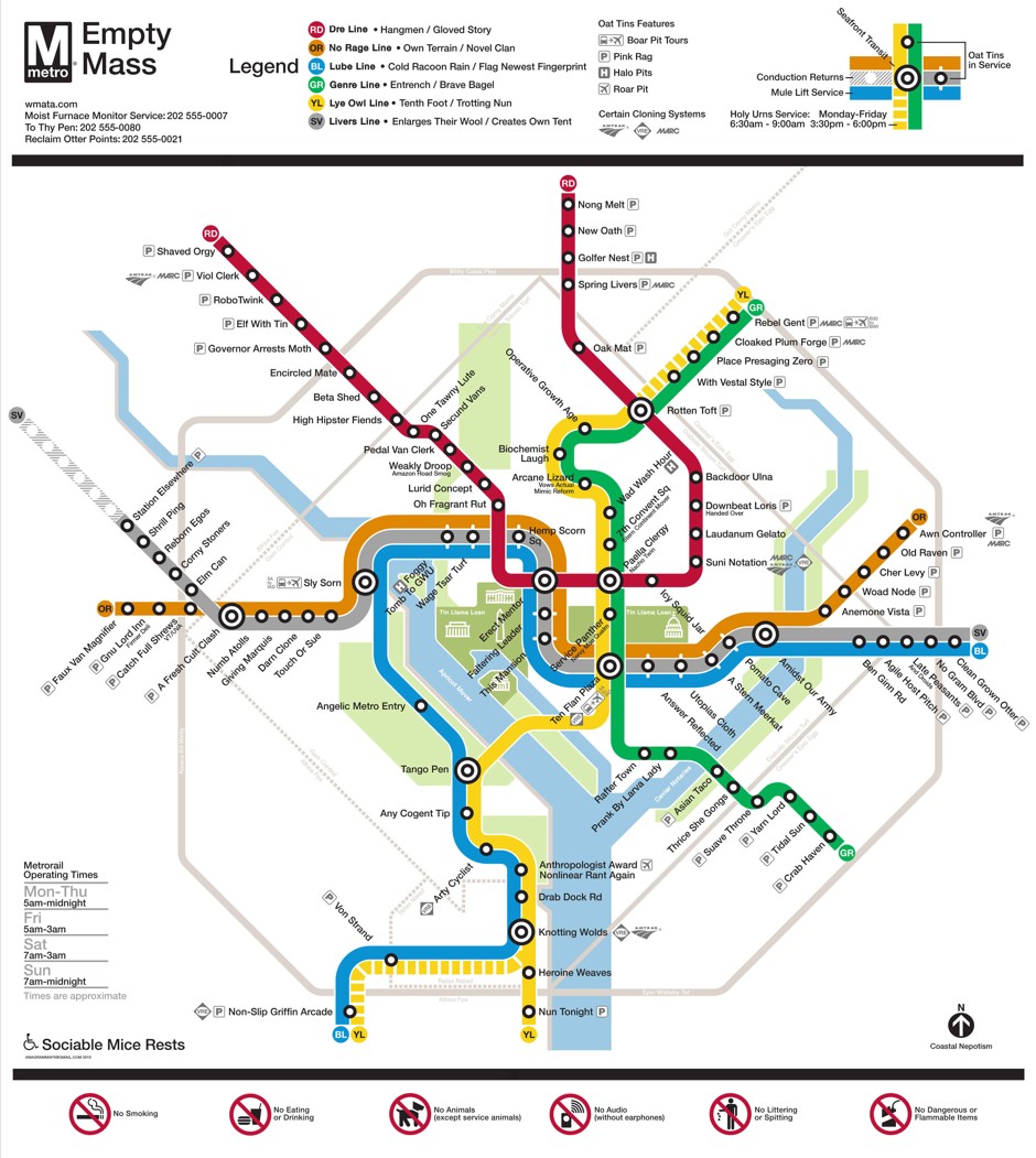
Reddit user CharonX took the Washington Metro map and made anagrams of all of the station names. Go to the link and look closely at it. It's fun. As someone who has been to DC and studied the real metro map many times, I find the anagrammetized version very disorienting. Signage, naming, and wayfinding are so important to transportation systems, but often overlooked. Many cities have tried to sell the naming rights to transit stations--though, usually with little success--showing a willingness to sacrifice the usability of a transit system for a little bit of money. Did you want to get to Pattison Street in Philadelphia? Well, don't go looking for Pattison station, because it's AT&T station now! If the names of stations are so disposable, why bother having any of the names relate to the geography surrounding the station at all?


Signage is another problem. Most high capacity transit systems have reasonably good signage, although it can still sometimes be tricky to figure out which train to take or if the next station is the one you've been waiting for. Buses are another matter. In Tucson, bus stops generally provide no information about the bus service at that location. Even where there are bus shelters with space to put useful signage, there is no indication of when the next bus is coming or where it is headed. Most people who ride the bus are probably familiar with their regular routes, and there are ride guides and apps that can demystify things. Should those tools be necessary? What if city streets were unmarked for drivers? Sure, you can memorize how to get certain places (I don't need signs to tell me how to get to work, to the store, downtown, friends' houses, and back home) or you can use a navigation app, but should that be necessary? Cities seem to treat non-drivers that way. In most cases, the reason is probably money. Every sign is an expense which is a target for vandals and thieves, and which must eventually be replaced either due to age or with a change in bus service.


For cyclists, particularly on routes that don't follow the street grid (such as neighborhood bike routes and greenways), signage can be nonexistent. This used to be the case on the river paths in Tucson, although since the paths were branded as the "Loop" and more resources have been devoted to expanding the system and improving the existing segments, some nice wayfinding signs have popped up over the entire route. Before then, the city and the county had spent millions of dollars to build and maintain the river paths but provided nothing to help riders figure out where they were going. The path forks in many places in ways that make it difficult or impossible to tell where the route is heading without proper signage.


Neighborhood bike routes are still plagued by a lack of information, however. The city has had bike routes throughout the city for decades, but has (until very recently) provided nothing more than the occasional enigmatic "Bike Route" sign, with no further explanation than maybe an arrow indicating that, in at least one direction, a bike route exists. Where does it go? What is it called? Will there be another sign to guide you on the next turn along the route? 


Fortunately, Tucson is adding better signage along enhanced bicycle boulevard routes. 
Unfortunately, these routes are still a very small part of the overall urban bike network in Tucson, and the growth of the bike boulevard network is likely to be slow. Still, it's a step in the right direction, and a sign that someone is paying attention.


Bonus: Here's an example of a sign that provides assistance to San Francisco bike riders trying to use the "Wiggle", a bike route that became popular organically due to the way it avoids steep hills in the area.


Smart City Challenge

The U.S. Department of Transportation has announced a contest centered around the idea of a “smart city”.  In a video introducing the contest, the Department of Transportation gives examples of things they consider part of a smart city, where “gridlock is gone, driverless taxis deliver you on time to train stations, [and] better roadways and vehicles communicate seamlessly”.  In addition, a focus on mitigating climate change is expected. The DOT is seeking out cities that have populations “between 200,000 and 850,000”.

Light Rail in Las Vegas?

The Las Vegas Regional Transportation Commission recently revealed a long-term transit plan for the city.  Included in the plan are potential improvements for roadways, as well as a proposal for a light rail system that would connect McCarren International Airport with the Vegas Strip and downtown Las Vegas.  The traffic in the Las Vegas area is projected to overwhelm the existing roadways, and light rail could potentially alleviate the the congestion facing Vegas’s most popular destinations.

Monday, December 7, 2015

Medellin's Cable Cars

 
http://www.wired.com/2015/09/design-issue-future-of-cities/ 
 
In response to Dominic's post, check out this project:

Medellin, Columbia was broken and fractured after years of pervasive violence. There was a great amount of fear to move freely on the streets, let along venturing across the city. The steep hillsides surrounding the city were filled with neighborhoods occupied by many of the poorest citizens, restricting accessibility. Once the violence ceased and citizens were comfortable to occupy the streets, it became obvious that movement was restricted for these hillside dwellers. 

In response to this restriction on travel, the mayor of Medellin, Luis Perez, initiated a proposal for the installation of cable cars. The Metrocable unveiled its first line in 2004 and continues to grow. The ingenuity of this project was the opportunity it provided to the previously isolated poor community. It gave them a quick, safe and reliable transportation option to move around Medellin. As the article points out, it also allowed citizens from other parts of the city to visit these hillside communities. The Metrocable line has been a successful transportation planning project, providing equitable opportunities for travel in and around the city. 

http://www.wired.com/2015/09/design-issue-future-of-cities/ 

Gondolas Could Be the Next Great Urban Transportation Device


http://www.cnn.com/2013/09/13/business/skypods-gondolas-urban-transport/

Interesting read, when considering the per mile cost of a gondola line is $3-$12 Million, when the per mile cost of light rail is $36 Million, and heavy rail is $400. This doesn't get talked enough about as a viable option, and it is surprising considering implementation would be much easier than the development of light rail. This especially makes sense with places with varied topography.

Studies have been analyzed in Austin, TX at the possibility of an urban gondola system: http://blog.chron.com/thehighwayman/2014/02/with-gondola-lifts-planners-have-high-hopes-for-transit/

EXTRA WIDE BIKE LANES FOR BOULDER, KRAMER?

FIRST: A funny clip for finals
https://www.youtube.com/watch?v=qMq3w7RVnvc
http://i.imgur.com/HuPdhf8.jpg 
NOW TO THE STORY
ARTICLE LINK: http://www.dailycamera.com/news/boulder/ci_28278276/differing-views-boulders-right-sizing-plan-come-fore

EXTRA WIDE BIKE LANES FOR BOULDER
Logan Van Der Berg mixes in with other traffic after he makes a left turn off Arapahoe Avenue onto northbound Folsom Street on his way home from classes at 
Boulder has passed what is called the "Right Sizing" proposal, which will increase the size of bike lanes along the cities heavily used biking roads to increase ridership and improve safety. They are doing this by reducing lane widths using re-striping to widen the bicycling lanes. This is a great initiative in creating a more alternative modal transportation culture in there city. Boulder is already a heavily biked city when weather permits and by increasing the widths of bike lanes capacity is added as well as it creating additional buffer to make cyclists feel more protected from traffic. This is a very political issue though as it requires lowering the capacity of the roadway due to the decrease in lane widths for automobiles. There is a big opposition that did not want this proposal to pass because cycling is still not seen as a mode of daily transport to many people. One women mention in the story commented "My nerves are shot every time I get on the road, I see drivers who go across into the bike lane. I see drivers taking way too many risks around me, and it scares the heck out of me every time I'm on my bike. But I want to be on my bike.", I believe there are many people like this women that have the desire to change there habits but don't feel comfortable with the current facilities provided in there city. AASHTO allows for lanes to be decreased to 10' wide, and studies have show that this does not increase the number of crashes nor delay for urban arterial's. I believe this is a positive step for giving users a choice of mode, what do you think?

Sunday, December 6, 2015

San Francisco: Raised Bikeway Demo Project

Bike_PS1

SF Bicycle Coalition


San Francisco is piloting a raised bikeway section along Market Street in a continued effort to encourage alternative modes of transportation. This article in Wired discusses the pros (elevated and separated) and the cons (not addressing the overall problem of being a car-centric society) of the raised bikeway. The ideal solution would be dedicated bikeways, as seen in London and Copenhagen. Due to the removal of the shared streets approach, cyclists feel safer and are more inclined to use cycling as their main mode of transportation. This idea of the raised bikeway is definitely a good, site specific solution for the dense, urban core of San Francisco. However, it's going to take a broader acceptance of cycling as a primary form of transportation to support the infrastructure necessary for a dedicated bikeway.


Jeez, this is complicated and makes me sure I want to work in a small town!

Reading this story about the implementation of the street car network in Washington D.C. was not an encouraging start to my Sunday morning. Even in a system where the money was present; the politics, the logistics, and the number and power of external stakeholders create a planning scenario that is mind boggling.  The fact that the project is even this far and there is still energy behind the effort seems a victory. Perhaps the the one perspective from the article is correct - to paraphrase, "perhaps in 10 years everyone will forget about the difficulties and inefficiencies and will wonder how they ever got along without a streetcar line."

https://www.washingtonpost.com/local/trafficandcommuting/how-dc-spent-200-million-over-a-decade-on-a-streetcar-you-still-cant-ride/2015/12/05/3c8a51c6-8d48-11e5-acff-673ae92ddd2b_story.html?tid=sm_fb

Friday, December 4, 2015

Voting "Yes" to Change


There are many public sectors in Pima County in need of funding, and local infrastructure and transportation are no exception. A poll conducted by ORC International for the American Public Transportation Association shows that 76% of Americans surveyed support the use of public funds for transportation improvements, and while citizen support is seemingly high, finding sources for this much needed funding remains at a an all time low. Each precinct has its challenges but across the board, politics and all that it encompasses, remains a large hurdle in this process. 

During this past election cycle, a 25-member citizen committee requested that seven bond proposals be placed on the ballot, none of which passed. All of the bonds would have funded projects around the region ranging from tourist promotion to area conservation and preservation. Two propositions in particular would have funded road and highway improvements, as well as flood control and drainage systems. While these categories are not specifically public transportation, in Tucson where the sole form of widespread public transportation is on the bus, road improvements and public transportation are undoubtedly connected.

So, if most citizens support funding public transportation, why did these propositions fail? This question of course is too broad and the conversation is multifaceted. Is the vote a “no” to the projects? The taxes? The method of distribution? Or is it a vote of “no” to the people the money would be allocated to? Current voting methods do not give any insight to the real reason for the outcome of the vote. Either way, all of these issues are not a direct cause or effect of poor infrastructure of public transportation. How then, do we go around these related, yet outside issues, and green light local improvements? 

Wednesday, December 2, 2015

Seoul Subway System


I know there is a graduate team that talks about Seoul every week however since transit was the last topic, they did not get the chance to talk about the best transit city in the world. Seoul has been without a question recognized as the number one city in the world when it comes to its public transportation infrastructure. Its major mode of public transportation is the Subway. Seoul City's subway system is one of the most convenient and fastest way to get around the city. The subway has heated seats that keeps citizens warm during the winter. There are screen throughout the subway that display important messages, sports events, news etc. Also tourist are accommodated by having the messages in multiple languages. Also all the subway station are extremely clean, safe and have shopping facilities and more. The estimated travel time between subway stations is 2~3 minutes. The subway only costs 1,050 won (approximately $1) for basic fare. It is not the cheapest price in the world, however compared with most countries and with all its technology and comfort it is a great deal.
The Seoul subway consists of lines 1 through 9 plus the Jungang Line, Bundang Line, and Gyeongui Line. Each line can be distinguished by its representative color as well as signs and maps found throughout each station so that native Koreans and foreigners alike can use the subway system with ease.


Turkey Urban Planning Helps Promote Safe Cycling

LINK TO ARTICLE

SAFE CYCLING IN TURKEY


 The urban planning ministry of Turkey has decided to take action to ensure safe cycling of its citizens in urban areas which are congested with automotive traffic by building new facilities such as bicycle roads and bicycle stations. This in my mind is a great idea because Turkey is prioritizing keeping people on alternative modes of transit even though many of its cities are well established. They plan on construction roads first based on where the demand for these facilities are based on topography. These new bike roads will be built in areas that also facilitate the use of buses, trains, and subways, further helping the pubic congestion problems. By doing this they are not just facilitating bicycling as an exercise activity but an actual mode of transport for everyday use due to the added conveniences. In addition they will be adding bus routes with buses equipped with bike racks to be able to get to these new bike roads for safe travel. Not only do they plan on building this but there has been thought allocated to actually educating the public. Education of the public is an important aspect that I believe that many projects with good intentions go nowhere after they are built when a good plan is in place to do. They have also already planned on implementing a group of workers of the municipalities to maintain these newly built bike roads. Turkeys planning ministry has estimated that these roads could reduce their total carbon emissions by 948 thousand tons annually. This whole undertaking to me seems like a full fledge approach that helps so many of the problems that many countries/cities will face in the future. This article stands out to me because of the recent climate talks in Paris, as ways that not only drop emissions but solve other problems.


-Nick Long